 Matt Ruta
Mt. Nelson Scramble

Note: This trip report has been sitting as a draft for months, though I’ve only now decided to publish it. The ascent itself took place July 23 2013. All photos courtesy of Oliver House’s iPhone.
Mount Nelson is a peak that caught my attention very quickly while working at Panorama Resort near Invermere, BC. It taunted me at work, a spectacular square topped pyramid rising over 2000m from the valley floor. Within a few days it was decided – I was going up that thing just as soon as I could trick someone into coming with me. Well, that and when the snow melted.
The route is described in Hikes around Invermere & the Columbia River Valley by Aaron Cameron and Matt Gunn, which was my primary source of information, along with Sonny Bou’s site and the information referenced therein. Things lined up to have a go at it on July 23 with co-workers Ollie and Kevin. Unfortunately, Kevin would end up getting hurt at work before getting a chance to go, so it looked to be only Ollie and I. Since we lived only 25 mins from the trailhead, we drove up the day before after work to have a look. The word online was that the road was out about halfway to our destination, however this turned out to be a lie. What was wrong with the road was that someone had built a barrier for a washout several km further that did not affect our route. ATVers had already carved a track out and some smashing and piling of sticks later, we had Ollie’s Explorer sneaking through with ease. From there we easily found the trailhead just past the furthest drivable point on the Delphine Creek FSR. I’m fairly confidant that any vehicle could make it up there without too much trouble.
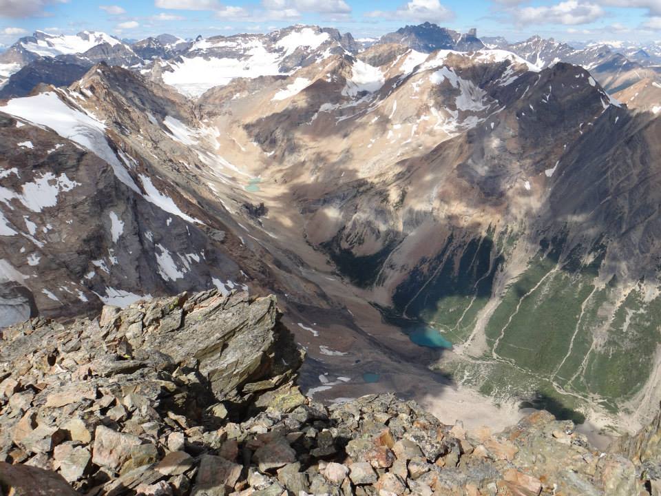
5:00 came early and we were in the car 45mins later. The Toby Valley is a reasonably hot place in the summer and the cool morning air was well received. Our attempt had gained the interest of another staff member who figured he’d have a go at it too. Boots hit the ground at around 6:15 and about 2 minutes later we made an unpleasant discovery. There is a nest of hornets or wasps under a log in the ‘trail’ and those suckers will not hesitate to go after you. If it is still there in the future, watch out. Ollie and I escaped, but our colleague was not so lucky, ending up stung several times. It was a horrible start to a section of climber’s trail described by Cameron and Gunn as “one of the most inhumane” they had ever done. It lived up to expectations too, providing a miserable 650m elevation gain in the first 90 minutes of the day. It was enough to do our (admittedly hung over) companion in, and once again Ollie and I became a team of two. The trail eventually exits the trees into a very long basin with another 700m of elevation to gain. Luckily, the basin is beautiful and route finding easy. We hardly noticed the meters tick by until, now about four hours into our day we reached a tarn at the back of the snow plastered upper basin, looking up at the final 650 or so meters to the summit. It actually looked a fair bit less daunting than anticipated, so we were perhaps less concerned with our ascent route than we should have been.

A look back the way we came as we ascend the basin.
The ascent, while straightforward was made difficult by our laziness, as we got a little off line in a gully that became more and more snowy and technical the higher we got. Both of us had foregone crampons and an axe, so several cruxes were negotiated with the help of a sharp rock as we wormed our way around a tongue of snow. Not recommended. I do plan to return and will still leave the crampons at home, but an ice axe would have been worthwhile. Oh well, we got through it eventually and traversed climber’s right underneath the summit block to gain the final pitch to the summit. This area was definitely the crux of the route for us, and we explored several horrifyingly exposed options on the southeast ridge before settling on a short network of steep chimneys and gullies further to the climber’s left. Route options here will be dictated largely by snow cover and are very loose. Rockfall is a concern on the entire route but nowhere more so than this final scramble. It is an avoidable one with good group management though, something that was easy for our group of two. The unnerving drop down the other side of the southeast ridge had me a little spooked and it was with a some relief that we scampered up the final scree slope to the spectacular summit. The view from here is difficult to put into words, encompassing endless glaciated peaks, many very recognizable Rockies and Purcell 11’ers, the spires of the Bugaboos, and a jaw dropping look several thousand meters straight down to the headwaters of Bruce Creek. We stayed for half an hour or so before getting chased off by a lurking rain squall making a menacing move towards us.
Staring down from the summit at Bruce Creek far below.

The Kloos family deserves serious recognition for getting the summit register/cross up there. It can’t have been fun.
The descent was actually very easy, with partner induced rockfall and snowpatch traverses being the main hazards. Again, an axe would have been handy here as the steep snow would have been ideal for a glissade had we brought a tool to prevent ourselves from plummeting to our deaths. Preferring to avoid such a scenario, we scree surfed and hopped down ledges instead. Now on a proper line marked by occasional cairns, we made reasonably short work of the face and returned to the tarn at its foot for a break. The squall amounted to nothing, and we retraced our many steps back down the basin and initial slog. This final section’s miserable climb was surmounted only by its agonizing descent. We hated every minute and carefully dodged the hornet’s nest with our quads and knees screaming. Certainly the worst part of the day. 8.5 hours after we left it, we were back at the car and the beers we left chilling in the stream. We couldn’t help driving home via the T Bar in the Panorama Village for some aptly named Mt. Nelson Nachos, which seemed rather appropriate. Definitely a highly recommended peak, despite the long approach and significant elevation gain.
